
A rather slow moving area of low pressure moving along the US eastern seaboard will gradually spread a wintry mix of precipitation and strong east to northeast winds across the Maritimes on Tuesday (not reaching Cape Breton until late evening). Environment Canada has issued Freezing Rain warnings for most regions of the Maritimes. Along the Atlantic Coast of Nova Scotia, the precipitation will change rather quickly to rain; with rainfall accumulations of more than 50mm anticipated. A rainfall warning is also in effect for the Fundy Coast of New Brunswick; although the changeover to rain may not take place until after 3 to 6 hours of ice pellets and freezing rain. The changeover to rain will gradually take place elsewhere over the southern Maritimes, but not before some areas receive 6 to 12 hours of freezing rain and ice pellets.
. 
In Northern New Brunswick, no changeover to rain is expected.. so prepare for wintry precipitation to persist well into Wednesday.
IMPACTS
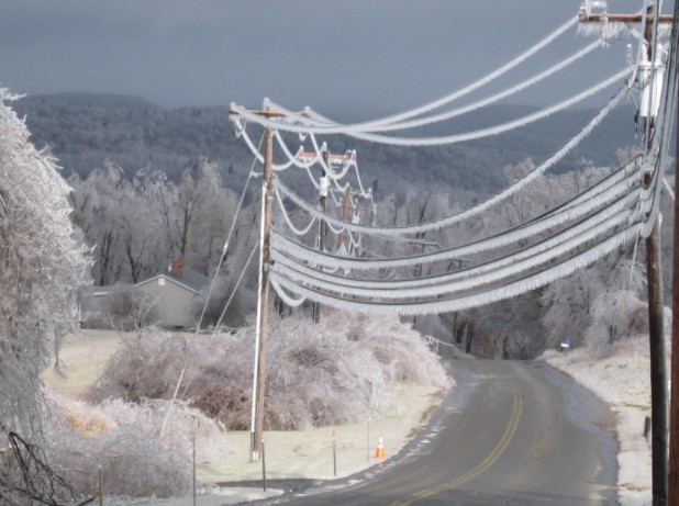
Freezing rain and Ice pellets will persist for extended periods of time (4 to 6 hours) in the Annapolis Valley, central and northern parts of Nova Scotia, and even longer in many communities in central and southern New Brunswick and parts of Prince Edward Island (6 to 12 hours). While even a short period of freezing rain will make untreated surfaces very slippery, extended periods will result in ice buildup on trees and power lines: prepare for possible extended power outages. Wind gusts of 75km/h will add to the outage risk. Flights will also be disrupted due to freezing rain.

Freezing Rain accumulation
Over Northern New Brunswick, mixed precipitation will persist and snow ice pellets will accumulate to a 10 to 15cm dense layer, difficult to remove and making road transportation challenging.


The heaviest rainfalls along the Atlantic and Fundy coasts will also make driving challenging with pooling of the water. Check your basements and remove any valuables, since some local flooding is possible.
In summary, travel is not recommended once the precipitation begins Tuesday, with hazardous driving persisting through Wednesday in Northern New Brunswick. Extended power outages are most likely away from the Atlantic and Fundy Coasts.
Prepare and Stay Safe
Jim
#weather
