This week, in my previous post, as well as tweets, I have discussed the uncertainty associated with Ocean storms. There is relatively little weather data over the ocean, and only a small shift in the track of these storms can result in a large change in snowfalls.
Those of you watching the radar in Nova Scotia Tuesday, appreciate the close call as the storm that affected Boston passed by to our south.
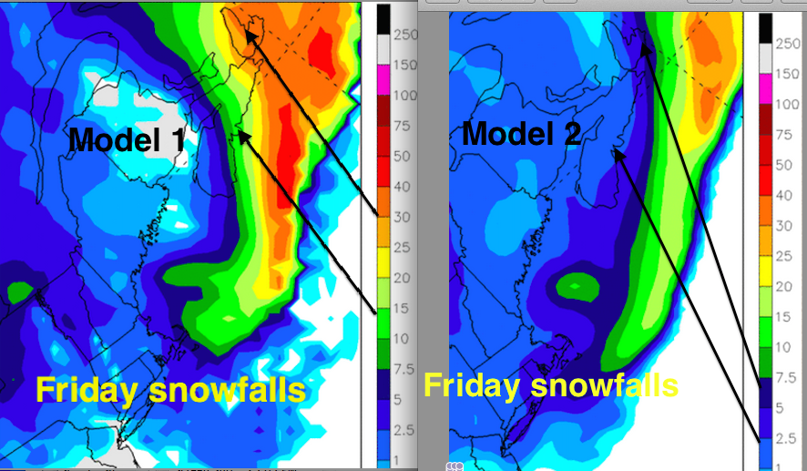
Friday’s storm will develop off of the USA eastern seaboard, passing south of Nova Scotia; not moving over land until it hits Newfoundland Friday night. To provide a snowfall forecast, an effective strategy is to consult an ensemble of computerized weather simulations, generated by models in Canada, the USA and Europe. However, when snow amounts are shared (media or social media) more than two days in advance, they may be taken from only one specific model. Since there is usually a spread in the model predictions (like on the image I have shared), there can be quite a range in the snowfall forecasts you are receiving. While this can be confusing, it also provides you with some appreciation of the uncertainty.
In order to minimize that confusion, Environment Canada seldom publishes snowfall forecasts more than two days in advance. Rather, it has become a regular practice to advise the public of a potential threat in a Special Weather Statement.
Once the storm is forecast to hit in the next day or two, Environment Canada will assess the situation and provide an official prediction of snowfall amount. Amounts of 15cm or more justify a Snowfall (or another winter related) Warning. Given the timing of Friday’s storm, expect those details in the early morning forecast on Thursday.
While the dome of cold air over the region does tend to keep storms to the south, the snow that does fall into this cold air tends to be “fluffy”. Fluffy snow is less dense (has less water in it), which makes it easier to shovel. However, it also blows around more easily, reducing visibilities and piling up in drifts. Fluffy snow, while lighter in weight, can also end up being deeper because the snow is less compact.
Expect the snow on Friday to be “fluffy”…

So the two model predictions I have included in this image tells us a few things:
- There remains quite a bit of uncertainty!
- Cape Breton is more likely to get a significant snowfall (but not guaranteed)
- New Brunswick is least likely
- Snowfalls will very much depend on the actual track of the storm
- Since model runs today are tracking the low further offshore than they did yesterday, Friday 13th might spare us from a big snowstorm
- I will share that the European model, which is statistically the best performing model for a few days ahead, is in between the models I have displayed; along the lines of Charlottetown 5cm, Halifax 10cm and Sydney 15-20cm
There is another storm passing to our south on Sunday… the models are keeping it closer to the Nova Scotia coast; which could result in more widespread snow over all three provinces.
I’ll update this post again tomorrow as new information arrives: http://yhzweatherguy.ca/