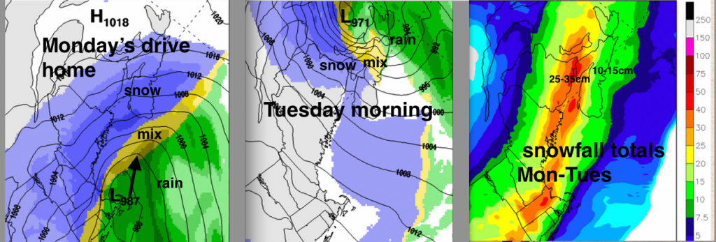
As Maritimers struggle to tidy up from two late January storms, the Groundhog will likely crawl back into his hole to avoid dealing with another messy storm.
Once again the low pressure centre will pass across Nova Scotia and move into the Gulf of St. Lawrence. New Brunswick will again receive only snow. In Nova Scotia and Prince Edward Island, there will be a transition to mixed precipitation. The Atlantic Coast of Nova Scotia and Cape Breton will likely change to rain with this predicted storm track.
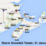
Snow totals will be highest in Southern New Brunswick, with Prince Edward Island and Nova Scotia inland from the Atlantic coast also receiving significant totals in excess of 20cm in many areas. Strong northeast winds in these areas will result in very low visibilities. While driving will also be very messy elsewhere in Nova Scotia, the combination of 10 to 15cm snow, freezing rain, ice pellets and rain will again make for a slushy mess difficult to clear.
The timing of the storm is such that the worst conditions will be overnight. However, snow will be starting in many communities ahead of the drive home.

As well, this storm is affecting the eastern seaboard of the USA as well as Toronto. Travel plans will need to be adjusted, and everyone should be prepared for possible outages due to the combination of mixed precipitation and strong winds.
Stay safe and pay attention to the Environment Canada Warnings: There is no uncertainty whether there will be a storm. Minimize the impacts by being prepared.