

The conversation associated with winter storms is frequently associated with snowfalls. While the storm on Sunday will certainly be accompanied by heavy snow, the combination with other severe weather elements will result in substantial impacts.
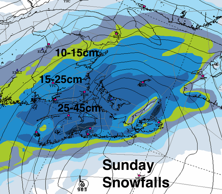
Snowfalls: The expected track of the storm along the Atlantic coast of Nova Scotia results in the heaviest snowfalls over the Southern Maritimes. Even along the Atlantic Coast, the snow will fall at very high rates Sunday morning (3-6cm/hr or higher) before it is expected to change to rain. Snowclearing operations cannot keep up with these high rates of fall, and visibilities are very low.
Some folks may receive 20-40cm snow in the morning before a changeover to rain (by late morning in Halifax). The weight of the snow my be a bigger problem than the depth.

Snow amounts may vary substantially as you move inland from the Atlantic Coast, and over higher terrain. While snow depth may not be as high along the Atlantic Coast, the weight of snow may be heaviest, especially after the rainfalls. Locations near the coast in Halifax, may only get 10-15cm of heavy wet snow, whereas the airport has the risk of getting 40cm.

Along the Atlantic coast and over Eastern Nova Scotia, the shift in winds to the southeast coming off of the relatively warm ocean waters, making a changeover to rain most likely there, with 20-30mm possible. At this point, there is no indication of warm air aloft of the storm, so freezing rain and ice pellets are a lower risk.

Very east to northeast strong winds will accompany the storm (gusts 90km/h). This would result in widespread blizzard-like conditions (near zero visibility). These winds might create a Storm Surge. The combination of very strong onshore winds combined with low pressure and high tide may be most pronounced along the Northumberland Strait. Since the Strait is ice covered, this storm does provide the risk of ice pile-up along the Northumberland coastline on Sunday.
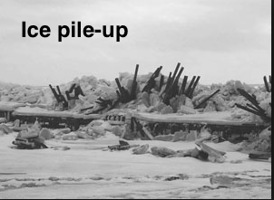
Ice pile-up from Storm Surge: Northumberland Strait

Timing: The snow will start before dawn in Halifax and southwestern Nova Scotia and southern New Brunswick, making its way elsewhere through the morning hours and into Cape Breton by lunchtime.
The changeover to rain expected to take place in late morning in Halifax… visibilities and winds will improve in Halifax in the afternoon and early evening before strong north winds and some more snow returns overnight and temperatures drop, freezing the slushy mess.

All indications that this is a very potent storm. Venturing out on the highways during blizzard conditions is extremely risky. Air and ferry travel will also be impacted. Extended power outages in winter require additional considerations for the potential loss of a heat source.
The additional snow (and rain in parts of Nova Scotia) will add to the existing weight of the snowpack, putting a strain on structures like roofs and decks.
Stay Safe, and pay close attention to the Environment Canada Warnings. I’ll update this post as new information becomes available.