

Quite a bit of sunshine in spite of a rather unsettled Spring pattern…
This afternoon clouds will thicken with some rain or showers that will mostly affect parts of Mainland NS.
The Fundy coast is perhaps the only part of New Brunswick that might get touched by a few showers. Rain amounts will be light; generally 5mm or less. The Tri-Counties of SW Nova Scotia might see 10mm. Otherwise expect a brisk southwest wind and temperatures close to normal for mid April: 8-11C Nova Scotia, 13-16C New Brunswick and 6-8 PEI. Temperatures are cooler along the coast.

A cold front will pass through tonight. A few showers may change briefly to a wintry mix over Cape Breton and Prince Edward Island.
This cold front will keep temperatures cooler for the weekend.
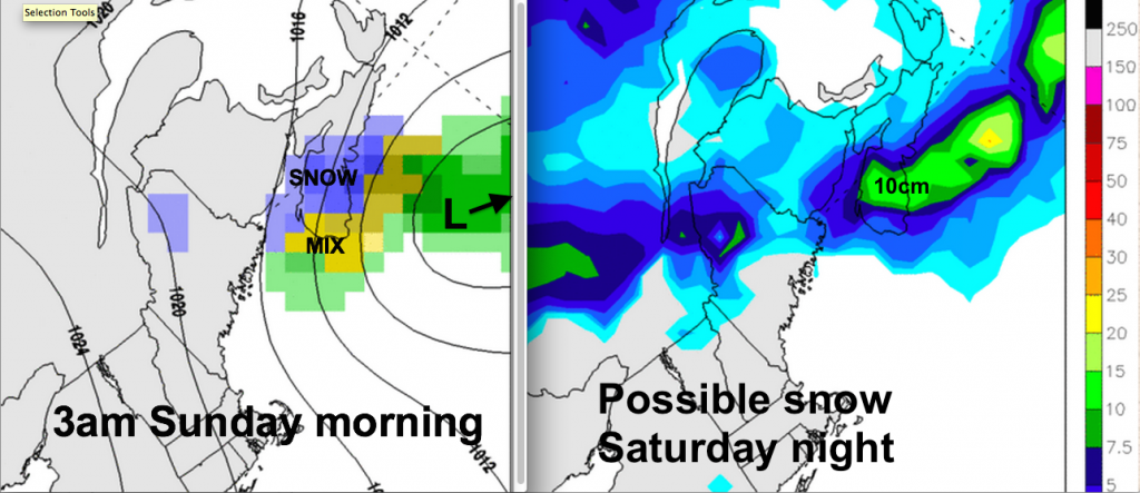
Saturday will have quite a bit of sunshine. However, the biggest uncertainty for the weekend is related to a low pressure area crossing western sections of the Maritimes Saturday night from North to South. This system is originating from Northern Canada with little data; therefore computer weather models are challenged to handle the details. About half of the models have almost nothing Saturday night; but some have up to 10cm over western Nova Scotia.

So folks in Saint John, Fredericton and Halifax may get a dusting Saturday night; higher accumulations possible in extreme SW NB and SW NS. Stay tuned… at least it will overnight!
Things should clear during the day on Sunday… but remain a bit cool.
Early next week will warm up slightly as a rain system approaches, then cool off a bit and remain unsettled.
