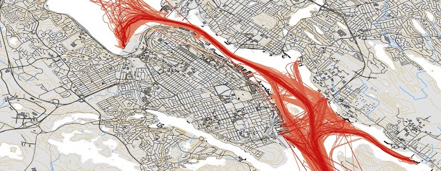
Recently I tweeted a map of 1 month of Halifax traffic from November 2011, and commented its due for an update. The latest data i have is from August 2016, so i Set out to Make the updated map. While Doing it, I also decided to Document how i did it.
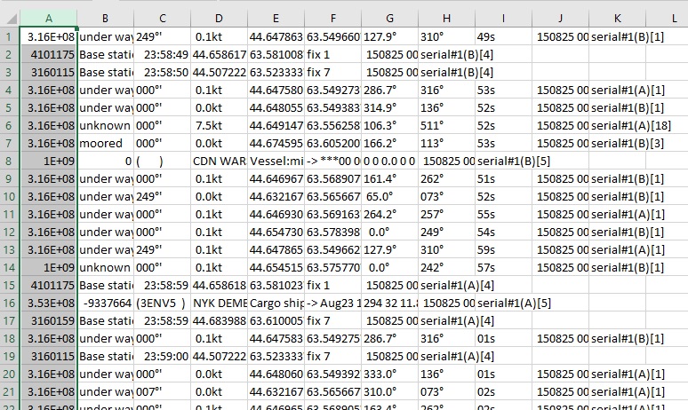
the first thing to do is grab the Log files from ShipPlotter. in my case the default location of C:COAAShipplotterlogs was used. Below is a small Excerpt from one of the Logs. A Days data is about 15mb of Raw txt.
316004240;under way ;249°'; 0.1kt;44.647605N;63.549313W;288.3°;316°;56s; 150801 000000;serial#1(B)[1]
999999999;unknown ;000°'; 0.0kt;44.654905N;63.576475W; 0.0°;241°;55s; 150801 000001;serial#1(A)[1]
316015715;unknown ;000°'; 0.0kt;44.660408N;63.585980W; 70.8°;317°;57s; 150801 000002;serial#1(B)[18]
316009640;under way ;127°'; 0.1kt;44.647850N;63.549675W;121.4°;314°;58s; 150801 000003;serial#1(A)[3]
316012656;moored ;000°'; 0.0kt;44.680828N;63.610840W; 52.3°;225°;58s; 150801 000003;serial#1(A)[3]
004101175;Base station 2016-07-30;23:58:59;44.658570N;63.581072W;fix 1; 150801 000004;serial#1(A)[4]
003160159;Base station 2016-07-30;23:58:59;44.683988N;63.610005W;fix 7; 150801 000005;serial#1(A)[4]
003160115;Base station 2016-07-30;23:58:59;44.507222N;63.523333W;fix 7; 150801 000005;serial#1(A)[4]
316022239;under way ;000°'; 0.0kt;44.646912N;63.569125W;258.7°;255°;01s; 150801 000006;serial#1(A)[1]
316002800;under way ;000°'; 0.0kt;44.648033N;63.549392W;349.0°;136°;03s; 150801 000007;serial#1(A)[1]
316031831;unknown ;000°'; 0.0kt;44.675977N;63.611325W;304.1°;105°;04s; 150801 000008;serial#1(A)[1]
316009640;under way ;127°'; 0.1kt;44.647853N;63.549675W;121.4°;314°;04s; 150801 000009;serial#1(A)[3]
316014180;under way ;000°'; 0.0kt;44.654475N;63.562032W;249.2°;154°;05s; 150801 000009;serial#1(A)[1]
316013960;under way ;000°'; 0.1kt;44.632167N;63.565667W;324.0°;073°;02s; 150801 000009;serial#1(A)[1]
999999999;unknown ;000°'; 0.0kt;44.654905N;63.576473W; 0.0°;241°;04s; 150801 000010;serial#1(B)[1]
316004240;under way ;248°'; 0.2kt;44.647602N;63.549310W;296.5°;316°;06s; 150801 000010;serial#1(A)[1]
316009640;under way ;129°'; 0.1kt;44.647850N;63.549675W;121.4°;313°;06s; 150801 000011;serial#1(B)[3]
316022239;under way ;000°'; 0.1kt;44.646912N;63.569123W;256.5°;255°;10s; 150801 000014;serial#1(B)[1]
316006196;unknown ;000°'; 2.4kt;44.647903N;63.567170W;334.0°;511°;09s; 150801 000014;serial#1(B)[18]
004101175;Base station 2016-07-30;23:59:09;44.658567N;63.581068W;fix 1; 150801 000014;serial#1(B)[4]
I choose the month of august, as it was the most recent full month i had. in the folder with all the .log files, run a simple copy command to combine them all into one big file. Due to the Size, I combined 6 days of data into one file.
Copy *.log bigfile.txt
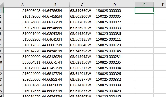
once combined, i use excel to grab the entries with a navigation status of “Under Way” I considered also collecting moored vessels, however just the underway vessels produced over 4 million lines of data in total. Once the csv file is open in Excel, I text to columned it, splitting on the semi colon. I then sort by by the Navigation status, and deleted all rows above and Below under way.
then i removed the excess columns, and saved back the csv.
after doing this with all 6 files, i combined them into one.
I then used notepad ++ to do a sanity check on my data – remove weirdness, and clean up the excess trialing comas. Once the underway data is collected, I combined the 5 files, and then added a Header row, to identify the MSMI, Lat, Long and the date. I am making this data available, and you can download it here: http://halifaxshippingnews.ca/AugPoints.csv (.csv 115mb) the data includes Lat/Long, Date/time and ships MMSI.
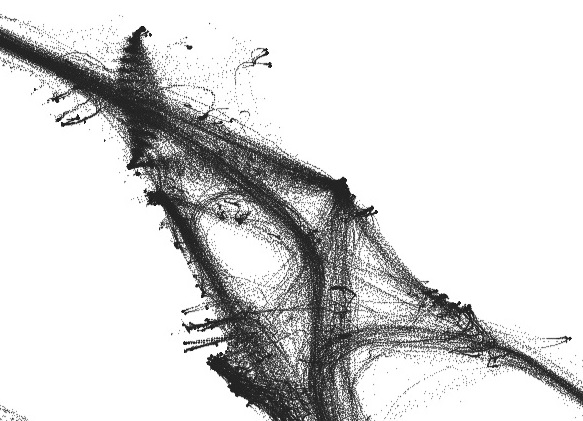
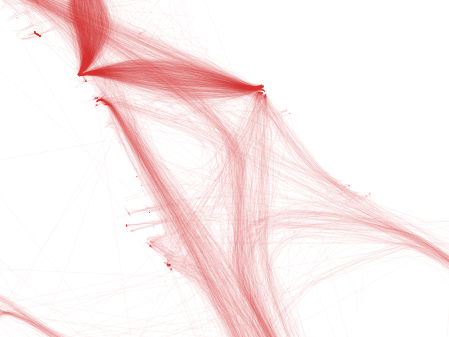
Once we have the points file, then we can move on to mapping it. – which didn’t work. oops. Need to get rid of the N, and W directional, and update to -63 to specify a west direction.
For this map, I grabbed QGIS – which is free, and created a layer from the XY Data. You basically get a Point Cloud.
The final Map used watercourse data from GeoNova,then the image was exported from QGIS. I then manually cleaned it up in Photoshop, removing the excess watercourses leaving only the shoreline. this is also where the labels and title block were added.
I should note the 2011 map was made in ArcMap. ESRI has made getting trial licenses a pain (And i have run out of email addresses) hence me turning to QGIS.
Original article: Making the Map.
HRP release: On December 6 at approximately 12:20 p.m., officers responded to a report of…
HRP release: On December 6 at approximately 12:20 p.m., officers responded to a report of…
Organising a move is always a complex undertaking, and when it comes to office moves,…
Source: Pexels One recent trend with regulated gambling platforms in Canada has to do…
Updated Dec 8 12:55pm Halifax Water release: The Halifax Regional Municipality is advising residents of the following update regarding the water…
Environment Canada release: 4:41 AM AST Sunday 7 December 2025 Alberta clipper to bring snow…