As discussed in my previous post, on Friday and Saturday, the situation with hurricane Matthew had changed. A cold front interacting with the storm caused flash flooding in North Carolina, and the moisture from Matthew was moving towards the Maritimes and being absorbed by the front.

Sunday morning
09 October
Weather models on Sunday picked up the possibility of a new low forming and intensifying, resulting on heavy rain and strong winds for parts of Atlantic Canada. Environment Canada issued a Special Weather Statement, which was upgraded to Rain and Wind warnings on Sunday.

Canadian Forecast Model
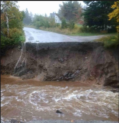
As it turned out, the combination of tropical moisture and cold air resulted in a rapidly intensifying and powerful storm with near hurricane force winds and extreme rainfalls. Cape Breton was the hardest hit in the Maritimes, with an area of extreme rainfall approaching 250mm and high wind gusts in excess of 100km/h developing.
On Monday morning, rainfall rates increased quickly in Sydney, and a line of heavy convective rain cells were lined up on the municipality (image of my tweet attached):

This unfortunately continued, until Steve Sutherland shared several tweets Monday afternoon alerting folks of the enormous disaster looming.

Steve Sutherland
CBC Cape Breton
A preliminary rainfall summary is attached. The 225mm in Sydney is almost double the normal October rainfall of 142mm, and shatters the previous one day record of 129mm set on 17 August 1981.

Storm Rainfalls
While there was a great need for parts of the Maritimes, like we have seen elsewhere in the world, the drought was followed by a flood. Climate change is increasing the likelihood of weather extremes.
This event will likely result in tens of millions or more in damage. It may be comparable to Hurricane Beth that had similar impacts in 1971.

The clean up will take days, weeks and months, with immediate risks including contaminated water, weakened trees and infrastructure… and eventually mold potential for flooded structures.
stay safe
Jim