
Southern sections of the Maritimes are experiencing bands of heavy rain on Thursday with mild temperatures . This is causing local flooding and pooling on the roads.

However, it will be the transition back to winter precipitation that will make things perhaps messier on Friday. A low pressure centre passing to the south of Nova Scotia on Friday will be shifting winds out of the North, which will drag in cold air.

As the low intensifies Friday evening, the winds will increase and the precipitation along the Atlantic Coast of Nova Scotia will change through freezing rain and then into snow near or shortly after midnight. The increasing winds will contribute to the elevated power outage risk caused by the change to freezing rain and wet snow. Needless to say, driving conditions will be poor on Friday, even in the rain, which will be heavy at times.

Snowfall totals will depend on the exact track of the low pressure system. There is some slight but important uncertainty as to where the heaviest snowfalls will be.

Northern Nova Scotia, PEI and Southern New Brunswick are at greatest risk of high amounts. The amounts on the charts are amounts of water equivalent (mm) in the snow. Typically that would translate into depth (i.e. 20mm would be about 20cm). However, wet snow is more dense and heavy. So 20cm of snow might contain 25mm or more of water. Regardless, the snow will be heavy!
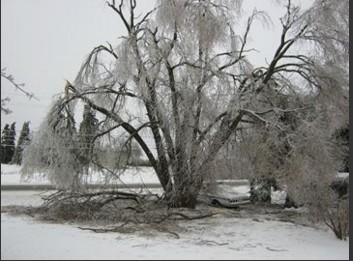
Freezing rain timing and amounts are also uncertain. The worst case scenario has a wide area of amounts over 10mm, which would be very hazardous!

Environment Canada has issued a Special Weather Statement for much of the Maritime Provinces for Friday. Pay attention to warnings that they will issue later this afternoon.
Stay Safe
Jim