3:57 PM AST Sunday 07 February 2016
Blizzard warning in effect for:
- Halifax Metro and Halifax County West
Blizzard conditions with poor visibility in snow and blowing snow are expected or occurring.
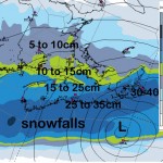
A low pressure system currently south of Cape Hatteras will intensify as it tracks up the U.S. eastern seaboard tonight then pass south of Nova Scotia Monday night. Snow associated with this system will begin near noon Monday over southwestern portions of the province then spread eastward through the day. High winds associated with this storm combined with snow will result in widespread reduced visibilities over the province. 20 to 35 centimetres of snow are currently expected over much of mainland Nova Scotia and Cape Breton before tapering to flurries on Tuesday.
Additionally this system will give higher than normal water levels and rough surf along the Atlantic coast of Nova Scotia Monday night.
Travel is expected to be hazardous due to reduced visibility. If visibility is reduced while driving, slow down, watch for tail lights ahead and be prepared to stop.
Blizzard warnings are issued when widespread reduced visibilities of 400 metres or less are expected for at least 4 hours.
Please continue to monitor alerts and forecasts issued by Environment Canada. To report severe weather, send an email to weatherASPC@ec.gc.ca or tweet reports to #NSStorm.
Source: Release
#99