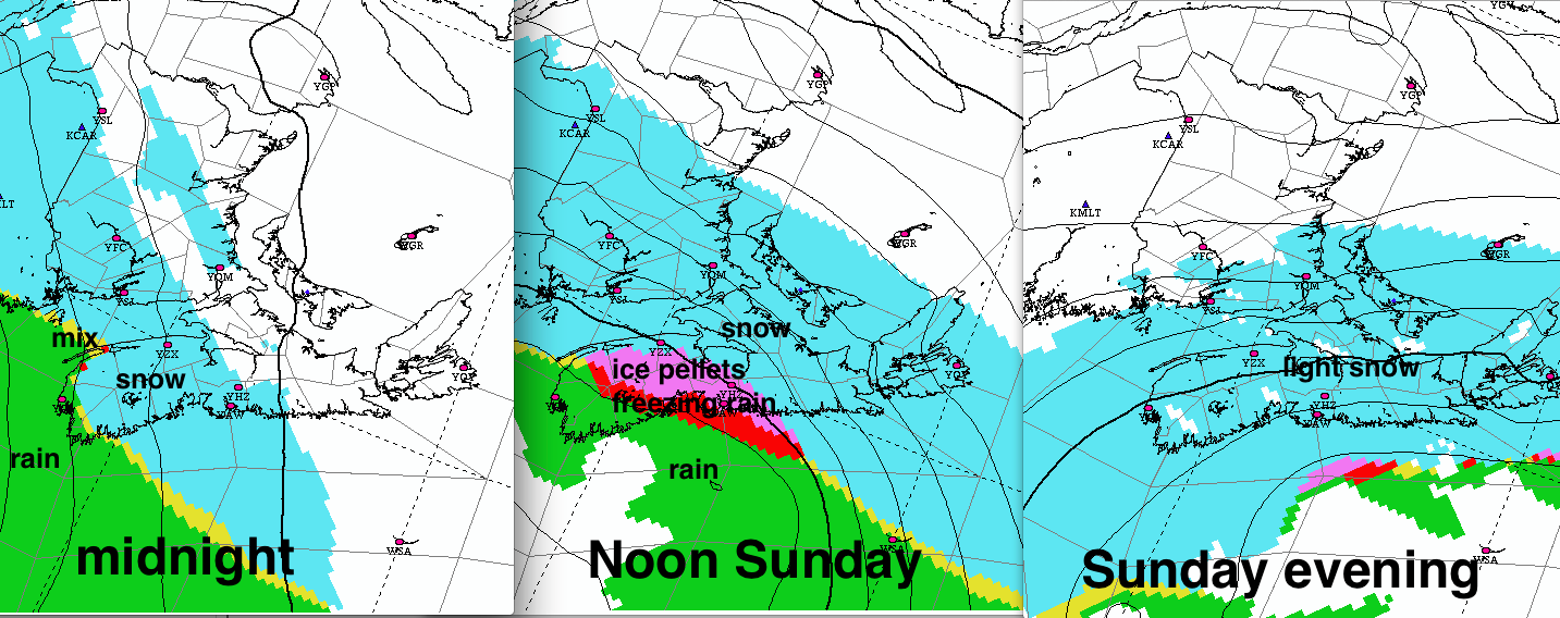
The low pressure area developing off of Cape Cod this evening will provide a nasty taste of winter, starting tonight. Light snow will begin over SW Nova Scotia and SW New Brunswick late this afternoon or evening, and change to mixed precipitation quickly over the tri-counties of Nova Scotia.
By midnight, the snow will intensify, with heavier snow and blowing snow will be covering all but northeastern New Brunswick and Cape Breton by Sunday morning. This heavier snow will spread across Cape Breton by lunchtime. As it does, the snow will have changed to rain or ice pellets/freezing rain in SW Nova Scotia.
Visibility may also improve in Halifax with a brief change to ice pellets, freezing rain or possibly rain in the mid morning or early afternoon. Light snow is likely to return before evening in Halifax. Better to clear first snow in early morning and leave a layer of snow before freezing rain or rain falls that is more easily cleared later.
Winds will increase with gusts to 70-80km/h over the southern Maritimes. Therefore, visibilities will be reduced with blizzard conditions with the heavy snow.

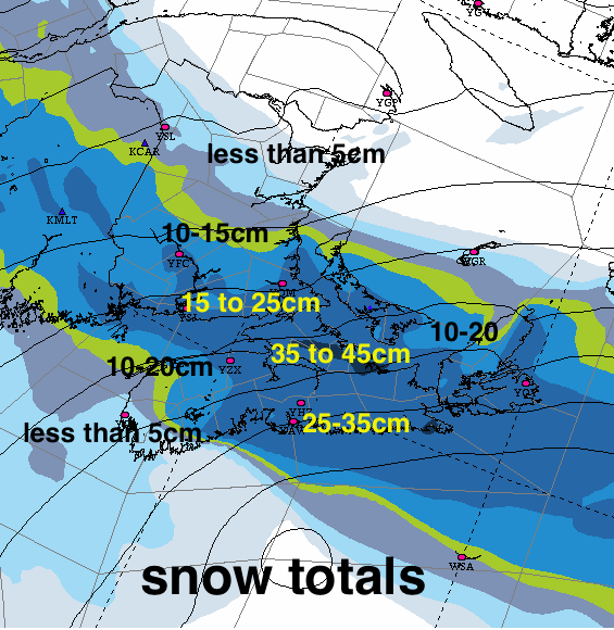
Snowfalls
The expected track of the low south of Nova Scotia would result in the heavy snow totals over much of the southern Maritimes Regardless of the snow amounts, the combination of snow and wind will result in significant and hazardous impacts.
Environment Canada has issued Winter Storm, Blizzard and rainfall Warnings advise the public to begin preparation. You should start preparations for the following possibilities:
TRAVEL IMPACTS
With Prince Edward Island and Nova Scotia beginning March Break, there are likely a large number of folks with travel plans this weekend. Anyone driving to Maine or Quebec may run into a bit of messy weather today, but nothing like tomorrow’s hazardous weather. Road travel would not be advised on Sunday.
Today’s flights should be fine, with perhaps some minor delays for flights connecting through Montreal or Ottawa.
Direct flights may be able to depart Charlottetown, but more likely Sydney Sunday morning before conditions deteriorate. All flights departing/arriving Halifax and New Brunswick on Sunday have the risk of being delayed or cancelled. While the visibility may improve Sunday afternoon in Halifax, flights will depend on aircraft operations and runway conditions, especially with freezing rain or ice pellets.
In situations like Sunday’s storm, airlines often allow passengers to re-schedule in advance. Travellers should check with their particular airline’s policy (e.g Air Canada).
Ferry traffic will be impacted by the strong winds on Sunday. The ice in the Cabot Strait may continue to be packed tight into the Cape Breton coast on Monday,
POWER OUTAGES
The strong winds on Sunday may cause some outages in the southern Maritimes. Any mixed precipitation or wet snow that could contribute to this risk is most likely along the Atlantic coast of Mainland Nova Scotia.
STORM SURGE/ICE PILE-UP
There is a slight risk that gusty east to northeast winds may produce storm surge flooding or ice pile-up along east or north facing coasts of Northumberland Strait and the Gulf of St. Lawrence with Sunday afternoon’s high tide. At this point the risk doesn’t appear to be extremely high, but coastal residents should remain vigilant.
I’ll tweet updates on Sunday, as well as updating this post should there be any significant changes.
Take care and stay safe