Snowfall forecasting is very difficult. Subtle shifts in wind direction from southeast to northeast can make an extreme difference in snow totals. While a storm of 1 million square km in size is well forecast, the difference between very heavy snow and nothing can be as small as 50km.
The computer weather models are based on some of the most advanced technology in the world, and are generated by the most powerful supercomputers. Meteorologists need to understand the physics of the atmosphere (including the likely density of the snowflakes!), local knowledge of the area, and the workings of these complex models.
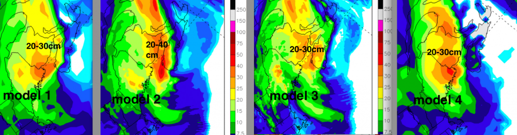
For tonight’s storm, there is a lot of certainty that Southern New Brunswick will get a good shot of snow (let’s say 20-30cm+). But what do you forecast for Digby (and the Annapolis Valley), Halifax or Charlottetown (or anyone else in NS & PEI)? Emergency managers need to know the most likely amount, but also the risk of very high amounts.

A reasonable consensus for a public forecast might be: Digby 20-30cm, Halifax 5cm and Charlottetown 15-20cm. However, model 4 has much less snow than that. Meanwhile there are scenarios that give Halifax more than 10cm and Digby more than 40cm. It’s important that an emergency manager is aware of all of these possibilities and the associated risks and potential impacts.
Since these models are publicly available, the extreme amounts can take over the conversation, rather than the honest discussion of variability and uncertainty. A reminder that highly trained meteorologists are working on your behalf to ensure your protection, and the Environment Canada Warnings should always be considered as very important advice: http://weather.gc.ca/warnings/index_e.html There will be a storm, and you should adjust your travel plans… and stay safe.
I’ll post a snowfall story Sunday so we can reflect on what happened. By the way, another interesting snow amount challenge coming Monday night, especially for Nova Scotia ![]()
There has been a lot of attention on the missed “historical blizzard” for New York City. This is a classic example where the peak amounts dominated the conversation, rather than the consensus, the uncertainty, and the risks. A couple of blog links: http://fivethirtyeight.com/datalab/how-meteorologists-botched-the-blizzard-of-2015/ and http://www.slate.com/blogs/the_slatest/2015/01/27/how_everyone_but_the_weather_channel_botched_the_nyc_blizzard_forecast.html?wpsrc=sh_all_dt_tw_top