Release:
4:43 AM AST Thursday 28 January 2016
Winter storm watch in effect for:
- Halifax Metro and Halifax County West
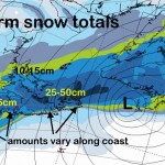
A developing storm off the southeast coast of the United States is expected to intensify as it tracks towards the Atlantic Provinces on Friday. The low is expected to pass just south of Nova Scotia Friday and Friday night bringing heavy snow along with it. Initially precipitation may start as light rain along the atlantic coast however it is likely to change completely to snow in the afternoon. The heaviest period of snow is likely to be during the afternoon and evening for eastern parts of Nova Scotia with 15 to 25 cm possible during the forecast period.
Rapidly accumulating snow could make travel difficult over some locations. Visibility may be suddenly reduced at times in heavy snow. Poor weather conditions may contribute to transportation delays.
Please continue to monitor alerts and forecasts issued by Environment Canada. To report severe weather, send an email to weatherASPC@ec.gc.ca or tweet reports to #NSStorm.